RSS

Monthly Archives: April 2012

LITTLE ROCK GOINGS ONS

I’ve been pretty busy lately but here’s a quick update of some things going on around town that I’m involved with

Bobby's Bike Hike

If you have been down to the Rivermarket recently you may have noticed the addition of Bobby’s Bike Hike in the southwest corner of the building. It is owned and operated by Little Rock native, Jeremy Lewno. Jeremy’s father, Bobby, ran a bus touring company here in town. Though born and raised in Little Rock, Jeremy has spent the past few years building Bobby’s Bike Hike in Chicago, which has become the biggest touring company in the city. Now he has moved back home to continue his success here in Little Rock. And yours truly will be one of the tour guides! So stop by check it out. We should start giving tours on saturdays very shortly. I have been studying like crazy to learn all I can about  the history of all the tour stops

..

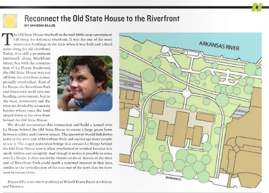
I have also been working on a side project with James trying to stir up some interest about a piece I wrote for the Arkansas Times’ Big Idea’s Issue back in January about bridging the chasm between the Old State House and the riverfront, more widely known as La Harpe Boulevard. But here is the piece I wrote.

Reconnect the Old State House to the Riverfront

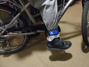
And Finally, Bike to work week Is coming up soon, May 14th through 18th, and Bike to Work Day is the 18th for those who may want to try it just one day. I’ll have some more info later, but there are a couple of different activities going on that week to try and get more people out on their bikes. And I am personally going to offer up 6 of these super awesome Bike Little Rock reflective bands!

I wear mine pretty regularly around town. Not only does it look cool AND lets people see me on the street, but it also keeps my pants leg out of the chain. Like I said, it’s pretty sweet. So I will offer up one each, to any three readers who bike the furthest to work that week and any three riders with the best (or most entertaining) bike to work story.

 
4 Comments

Posted by on April 30, 2012 in Little Rock


RISK NIGHT AT STUDIO MAIN

Let the battle for world domination  begin! Somehow I have successfully taken all of Europe. And yes we have a huge homemade board! This could be a long night.

image

 
1 Comment

Posted by on April 18, 2012 in Uncategorized


URBAN BLACKBERRIES

I always thought Urban Blackberries would be a great name for a band.

image

I took Beckett for a walk yesterday after work and on our way back we stopped to check out the blackberry bushes at the end of Gaines St. There’s a lot of berries growing but I was surprised when I found about a handful that were already ripe! Can’t wait till the rest ripens!

 
Leave a comment

Posted by on April 18, 2012 in Little Rock


LITTLE ROCK’S HISTORY: CARNEGIE LIBRARY RUINS

The Studio Main exhibit last Friday went well. We had a lot of great discussion with locals about Little Rock’s history. And even though the open house is over, I’m still on a bit of a history kick. So here’s another Little Rock’s History entry.

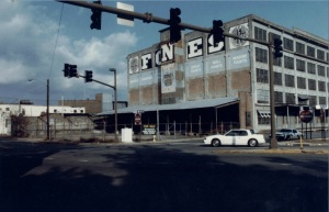
Little Rock’s Main Library sits in the heart of the Rivermarket District today, and along with the actual Rivermarket Pavilion  itself, was one of the earliest contributors to the revitalization of the district and arguably downtown. The Main Library was opened in 1997 in the renovated Fones Brothers Warehouse; one of the many warehouses that have been converted in the area. Just this weekend the building was packed during the Literary Festival with authors from across the state and nation giving lectures about their writing and signing books.

Today’s Library, is the third Little Rock Main Library building. The original Little Rock Library was one of the hundreds of Carnegie Libraries that were built across the nation and in other countries. There were four Carnegie Libraries built in Arkansas, two of which still function as Libraries, one that has been given a new use and one (guess which one) has been demolished.

Rex Nelson’s Southern Fried Blog has a pretty good entry about the Arkansas Carnegie Libraries as well.

.

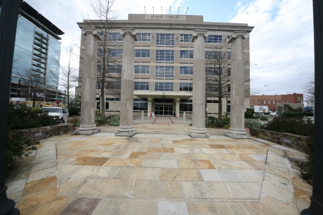
Little Rock’s Carnegie Library was built opened in 1910 at the corner of 7th and Louisiana.  It served as Little Rock’s Main library until 1964 when it was razed to the ground to construct a new modern library in its place. I guess I can be happy they didn’t tear it down to build a parking lot for once. But all was not lost. During the demolition, a local citizen, William Carl Martin, recovered the original four columns from the Carnegie Library. “Each column consisted of four sections that were hauled away, two at a time in Mr. Martin’s pick-up truck. He later donated two of the columns to Mabelvale High School, which has since released them back to the library.” (http://onlyoriginals.org/blog.html Count Pulaski Way Dedication. July 24, 2009). The columns were erected in front of the Main Library in 2006 and today, frame the entrance to the Library, acting as they did in their original location at the old Carnegie Library.

Carnegie Library 1910

The Carnegie Columns (Photo by Jeanne Marie Meyer)

But Wait! There’s more!

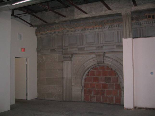
Most accounts of the old Carnegie Library talk about how it was totally destroyed to build the new Library. But this is not completely true. In fact, some of the old façade still remains, encapsulated in the new building walls. During a trip a few years back, John Greer at WER Architects and Charles Witsell explored the old library which was undergoing renovations to become a new data center and found the remains of the old facade. Thank John for providing the Pictures!

These photos appear to be either the North or South East or West Facade.

Today the site is the Little Rock Entergy Data Center. The ruins still remain hidden within the walls, waiting to hopefully be one day, rediscovered and recovered as part of Little Rock’s past.

 
7 Comments

Posted by on April 17, 2012 in Architecture, Little Rock


LITTLE ROCK’S HISTORY: DONAGHEY’S CAPITOL MISTAKE

Remember that saying, measure twice cut once?  If you ever need remembering, just look at our State Capitol Building. The history of the Capitol is another one of those, only in Arkansas stories. It was initiated when part of the plaster ceiling collapsed at the Old State House and the legislatures decided they needed to begin funding a new Capitol building. The site chosen for the new building was the location of the Arkansas State Penitentiary, which lead all sorts of joke about sending the politicians to where they belonged. The plans that were picked were actually a proposed design for the Montana State Capitol Building that ended up not being used. The construction was slowed for years by a governor who thought it was a waste of tax payer’s money. And once progress was resumed by a new governor, he had most of the existing construction ripped out because he did not like the architect! But probably the most notable feature of the Capitol’s colorful past that is still visible today is the Capitol’s alignment.


View down Capitol Ave

Most people know that the Capitol is centered at the end of Capitol Ave. It’s a beautiful view from downtown to see the dome rise over the hill, through the canyon of towers downtown and framed by the trees. The building is one of a handful of important structures that offer a grand termination point to the streets downtown, like the Old State House and the Governor’s Mansion at either end on Center street of the tower of Union Station at the west end on Markham. But as you move closer to the Capitol building something starts to look a little off.


.

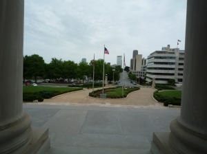
This is a shot standing between the 2 center columns of the Capitol, notice how the entry promenade curves to line up with the street?

Little Rock’s grid was based on the French model, which oriented the streets towards the riverfront rather than the compass points. This created the 9 degree shift that we have downtown today. The map below is from 1888. You can see the old downtown with the shifted grid as well as new subdivisions that had begun to spring up around the core, which were altered to be oriented towards the compass points. Even before this time, the state Penitentiary, which was started in 1839 and first used in 1842, was built on top of a hill to the west of town, overlooking the city below.

Little Rock Map 1888

State Penitentiary in 1887

So the story goes, when George Donaghey, who had been appointed the Capitol Commissioner, was in charge of laying out the foundations of the building, the center axis of the building was to be centered on Capitol Avenue. The problem was, though the prison had been closed already, the prison walls were still in place at the time. This was to act as a sort of construction fence but also to allow the use of convict labor without worrying about convicts escaping. Since there was no clear view of Capitol Avenue and this being Arkansas, Donaghey just eyeballed it with the help of someone at the top of the wall. No surveying equipment of any sort was used. To Donagheys credit, he was pretty close. The center of the dome is only a couple of inches off the center axis of Capitol Avenue. The problem was he didn’t take in account the fact that the city grid was not oriented the same at the penitentiary walls. So construction on the Capitol began with a foundation oriented North South and it wasn’t until the prison walls finally came down halfway through the project, the builders began to realize the front door wasn’t going to line up with the street.

Whoops!

So remember, Measure twice, lay the foundation for the most prominent building in the state, once.

And dont forget to come visit our History of Little Rock Exhibit at Studio MAIN this Friday (April 12th 2012) from 5 to whenever.

 
1 Comment

Posted by on April 12, 2012 in Architecture, Little Rock


LITTLE ROCK’S HISTORY: LOST TREASURES

Much of our exhibit consists of old photographs of great buildings in Little Rock that have been lost over time. One of these buildings was the Union Trust Building on 4th and Louisiana.

“The Union Trust Company, which started as a brokerage firm in 1885 moved to this striking art-deco style building at the northeast corner of Fourth and Louisiana Streets in 1929. The building, fronted with Minnesota granite, bore sculptures panels representing the progress of industry and agriculture. It became the Union National Bank in 1934; the firm moved to a comparatively bland skyscraper on Capitol Avenue in 1969. The architecturally significant building was razed in 1978 for the {a} parking lot…and Union National disappeared into a series of mergers with larger banks.”

Little Rock Then and Now by Ray Hanley

Union Trust Company Lobby

Advertisement From 1929 for Union trust Company Opening

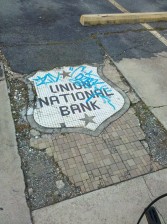
All that is left of the Union Trust Company Building (And another reason why I hate graffiti!)

I’m writing about this building in particular because of the interesting remnants of the building that remain on Fourth Street which I noticed on one of my wanderings. Thought the building is gone, the tile mosaic still remains in the sidewalk where the front entrance once was. This site is also significant because recently Moses Tucker announced they will be restoring the Blass building next door and this site will become a parking deck. Jimmy and Rett, if you’re reading this, please save this piece of history! It would be a great addition to this new development.

An empty parking lot is all that remains

 
Leave a comment

Posted by on April 11, 2012 in Architecture, Little Rock


LITTLE ROCK’S HISTORY: ARKOPOLIS, ARKANSAS

Many people have inquired about the exhibit title, “Almost Arkopolis” and where the name came from. The story behind it is that we were almost called Arkopolis! Come to our Open House Friday nigth uring the 2nd Friday Art wWalk at studio MAIN from 5- 9 to see the exhibit.

The story goes back to the early 1800’s when a trapper named William Lewis brought his family to the area which was known then as the “Point of Rocks” In 1812, set up a homestead and laid claim to the area. William was the first setter in the area of what we know today as Little Rock.

The Southwest Trail

The Point of Rocks was a crossroads in Arkansas, where the Southwest trail, which ran from St. Louis to Texas, forded the Arkansas River, and travelers on the river, transitioned between the flat delta to the more mountainous river valley region of Arkansas, making it a good location for a future town. The state was also slowly growing in population and on its way to becoming its own territory and a more suitable site somewhere in the center of the territory was needed to form a seat of government.

The Point of Rocks was becoming a very strategic location in the development of Arkansas and was soon realized by a land speculator named William Russell in 1819 who purchased the land to lay out a town called Little Rock. But William Russell was not the only interested party. Another group, led William O’ Hara (apparently William was a very popular name in those days), laid claim to the land based on the government issued New Madrid Certificates. After the great New Madrid Earthquake in late 1811, many people lost their property to which the federal government issued certificates to affected parties to lay claim to an equal amount of land anywhere in the Missouri Territory (Arkansas was still part of the Missouri Territory until 1819). So the New Madrid group laid claim to a site that overlapped William Russell’s’ claim. The New Madrid group started early building their town which they too called Little Rock, to try and get the upper hand on the dispute. But to differentiate itself from the proposed Russell town site, they changed their name to Arkopolis.

The town was built quickly to hopefully house new legislatures who would be moving to Arkopolis shortly, mostly consisting of log structures. But in true Arkansas style, there was a bizarre twist. While there were two different claims on the area causing the dispute, only part of the two claims overlapped. After many homes and buildings were built, it was realized that the town had actually been built on a section of William Russell’s claim that did not overlap the New Madrid claim. So one night all the men disguised themselves (I’m not sure why) and moved all the log structures 300 or 400 yards to the area claimed by the New Madrid group. Every building was removed except the one brick building in town, which was blown up because it could not be moved.

Eventually, the Territorial Superior Court ruled in favor of William Russell and Arkopolis faded into history.  All the buildings were destroyed in spite so that Little Rock could not use them. But the curious thing is, it did not disappear completely. Many old maps around 1820 – 1822 still show a city in the center of Arkansas called Arkopolis

1822 Map of Arkansa By S. H. Long showing Arkopolis, Arkansa (Open and zoom in)

I can envision a lot more ancient Greek influence in our architecture if we had been called Arkopolis. City hall would be the Arkopolis Acropolis!

 
Leave a comment

Posted by on April 10, 2012 in Little Rock


LITTLE ROCK’S HISTORY: A CITY IN A PARK

Next Friday, Studio MAIN will have its monthly open house during the 2nd Friday Art Walk. We had such a huge interest in the Little Rock History Exhibit, “Almost Arkopolis”, that we have decided to leave the exhibit up for another month so more people can come enjoy it.  And so I have decided to devote my blog this week to an entry each day about something in Little Rock’s history that most people may not remember or even know about. These will either be entries about things that I learned about while helping with the Studio MAIN project, or events or places that are seeing activity again recently.  So enjoy!

Three Trail Loop System

Because studio MAIN’s exhibit is really about planning history, I wanted to do this first entry to talk about previous master plans for Little Rock, primarily the city park system. The Little Rock Parks and Recreation department has conducted extensive research and planning for a coherent master plan for Little Rock’s Parks system. In 2001 a master plan was presented which revolved around the idea of a city within a park. The main structure consists of three trails, The Edge Trail, The Earth Trail and The Extreme Trail. The good news is we’re already a third of the way done with the master plan! The Edge Trail, which was proposed to follow the river edge the length of the city, is known by most everyone today as the River Trail. The second phase, The Earth Trail, will run through the Fouche Creek bottom lands to the south from the airport to Otter Creek  and the Extreme trail willtravel between the two trails from Otter Creek, north to the Arkansas River over the steep hills and valleys in west Little rock .

These three trails will create the framework for the rest of the master plan which connects different parks and green space throughout the city to one another and creates a network of green space throughout the city for a healthy, active and beautiful city.

City in a Park

But this plan is actually nothing new. In fact, a majority of it was based off a previous master plan nearly ahundred years ago that not many people even know about but which has played a leading role in most of the major planning develops in Little Rock throughout its History.

John Nolen's 1913 Masterplan

Not many people know about the master plan for the Little Rock Parks system that was designed in 1913 by the famous landscape architect and city planner, John Nolen. I wasn’t even aware of it myself until our open house last month at studio MAIN when local Landscape Architect, Bob Callans, told me about it. There is an exhibit on display at City Hall showing the overall master plan as proposed by John Nolen depicting a vision of a grand and green city. After seeing the exhibit I did some research online and found the actual master plan documents to share. I have attached the PDF below for anyone to download and enjoy themselves but I also have added some of the plans and illustrations below.


Report On A Park System For Little Rock Arkansas


Nolen's Plan

This is the overall master plan. It was a fold out map in the original document. But it shows a park system that connects different green spaces surrounding the city along existing creeks and wetlands, similar to the city’s current park master plan shown above. But there are some major differences. You will notice that this plan consist of greens spaces along the creeks but also green boulevards avenues and parkways that surround and spread through the city, making it not just a plan for parks but a true green city master plan. The new city plan also has a system of green spaces following the creeks, but notice the roads. They are shown as black lines that cut through the parks, leaving two separate systems, one for people and one for cars. Now this can be argued as good or bad I think, but it’s interesting to see how we have elevated cars so high in our society that they need their own system within the city to operate.

Along with the overall plan, John Nolen also drew up plans for specific entities within the city, specifically a new civic center downtown and a design for West End Park, the current location of Central High School.
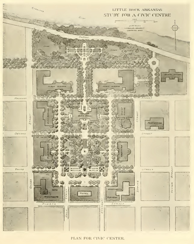
Study for a Civic Centre

City Hall was actually built pretty close to where Nolen recommended. The above plan shows it on the south side of Markham Street near Broadway. Today City Hall is on the North side of Markham at the intersection with Broadway. Notice the Courthouse and the Old Statehouse to the right which were already constructed at the time of the plan.
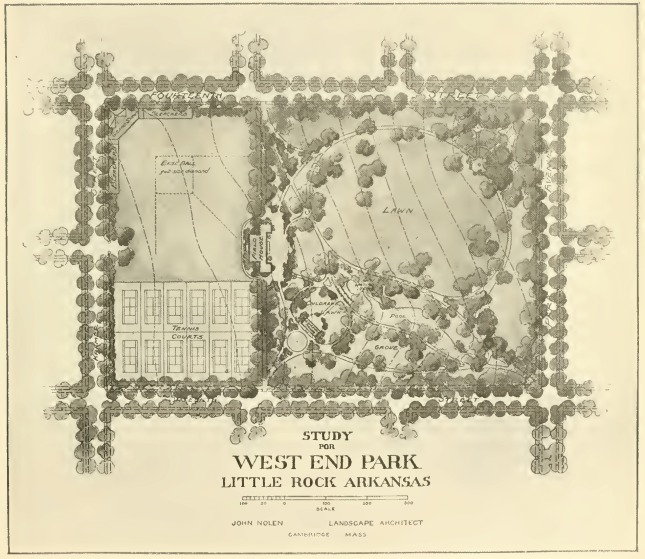
Probably the most notable design item for Nolan was his plan for a new Riverfront.  At that time, the riverfront was still seen as a commercial and industrial element of the city. The thought that the riverfront should be an enjoyable park space for the city was a new concept. 100 years later, Nolen would be proud to see the Riverfront Park that Little Rock boasts today!
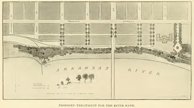
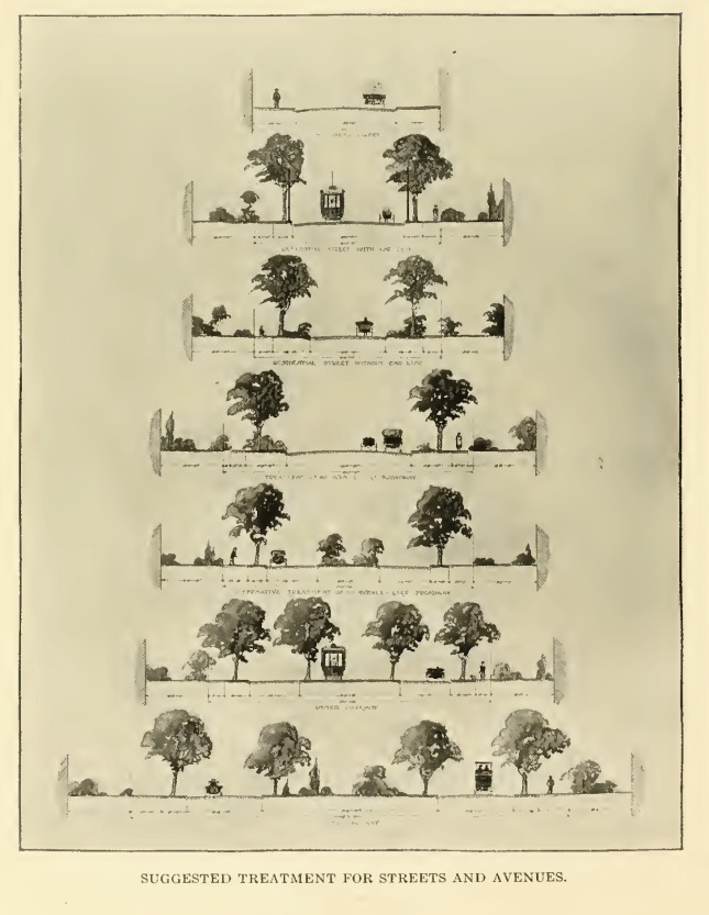
Finally I included a series of street cross sections proposed by Nolen for the different Streets, Avenues Boulevards and Parkways that he showed crossing the city. In my initial research for John Nolen, I ran across a few references about how the idea for I-630 actually can be traced back to a later John Nolen plan for Little Rock in the 1930’s. I haven’t seen this plan yet so I cannot be sure of what Nolen actually proposed, but after seeing these beautiful street type proposals below, I have a feeling he would be appalled at the concrete chasm that we have divided our city with.
I have to say I had a blast learning about this master plan and John Nolen’s role in our city’s history. We have come a long way and still have a lot ahead of us so come visit studio MAIN this Friday from 5 – 9 to see more of Little Rocks past and discuss our Future!
 
Leave a comment

Posted by on April 9, 2012 in Little Rock


FREEWAY DEMOLITION DREAM

I normally don’t post links to websites that preach good urban design because there are plenty of other blogs out there that do but sometimes they get skimmed over. I try and keep my blog local and unique. But James sent me this link from Arch Daily and I wanted to post it for anyone interested.

Demolishing Freeways and Reviving American Cities

It’s a short read about how freeways are basically doomed because they do not solve traffic problems. They actually make them worse in the long run. It would be hard to convince people to replace I-630 with a multi-lane boulevard, and maybe we’re just not big enough yet to have the sever traffic problems that other large cities are having which is leading to this trend of tearing down urban freeways, but it is a nice thought. I-630 is basically a wall or a chasm right now dividing the city in half. It would be great if we could tie it back together and create a beautiful boulevard through the city to be proud of rather than an ugly concrete freeway.

 
Leave a comment

Posted by on April 5, 2012 in Little Rock


BROADWAY BRIDGE PARK – UPDATE

Arkansas Times has a encouraging entry on their blog today about the Broadway Bridge. Mayor Hays and Mayor Stodola have expressed their desire for the Broadway Bridge to be converted into a pedestrian and biking plaza space and divert the traffic to a new bridge at Chester Street. There are already plans for a Chester Street Bridge to be built in the future as capacity grows, so why not build it now and help shift the heavy traffic out of downtown, rather than tear down a beautiful bridge, snarl up traffic for 2 years during construction and replaceit with an uninspiring disappointment?

Once again, it’s probably too little too late. I don’t know what could be done but it looks like one of those win win situations for pedestrians, cars, bikers and downtown!

Bridge Options


UPDATE: Tim McKuin’s blog, MOVE ARKANSAS has a pretty good entry as well with some renderings of what could possibly be!